
GPS Coordinates from Photo vs EXIF.im
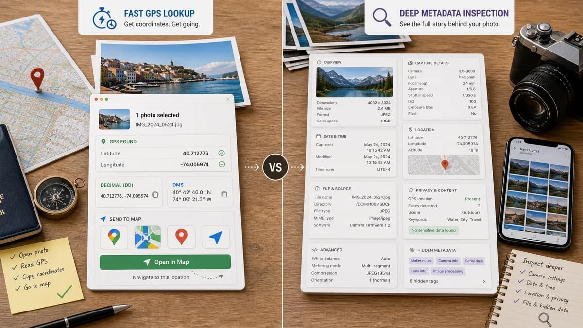
GPS Coordinates from Photo is the baseline in this comparison: Read EXIF GPS metadata from a photo and view latitude, longitude, DMS coordinates, altitude, and map links.
Compare a focused coordinate extractor with an EXIF inspector aimed at hidden photo metadata and privacy.
Quick verdict
Use GPS Coordinates from Photo for fast GPS lookup and map navigation. Use EXIF.im when the user wants to inspect broader hidden metadata categories.
How GPS Coordinates from Photo fits
GPS Coordinates from Photo is a focused browser tool for opening one image, reading EXIF GPS latitude and longitude, showing decimal and DMS coordinates, and sending those coordinates to common map services.
How EXIF.im fits
EXIF.im is an EXIF inspector for viewing metadata hidden in photos, including location data when GPS tags are present.
Side-by-side comparison
| Decision point | GPS Coordinates from Photo | EXIF.im | Takeaway |
|---|---|---|---|
| Primary workflow | Our workflowSingle-photo GPS coordinate lookup with the coordinate result as the main screen. | Competitor workflowInspect hidden photo metadata and understand privacy-sensitive fields inside an image. | Choose by the first task: direct coordinate answer versus the compared tool's broader workflow. |
| GPS coordinate viewing | Our workflowShows decimal latitude/longitude, DMS coordinates, altitude when present, and map links. | Competitor workflowEXIF.im can reveal location-related metadata when it exists, but it frames GPS as part of hidden metadata inspection. | Both can help when GPS tags exist, but our page keeps the coordinate output easier to scan. |
| GPS or metadata editing | Our workflowRead-only by design; it does not rewrite the photo or change GPS tags. | Competitor workflowThe compared workflow is inspection-first rather than a location metadata editor. | Use an editor or catalog app when the location must be added, corrected, removed, or exported back into files. |
| Metadata scope | Our workflowFocuses on GPS-relevant EXIF fields and hides unrelated metadata noise from the main result. | Competitor workflowIt focuses on hidden EXIF and privacy-sensitive metadata categories, including GPS when available. | Broad metadata tools are better for audits; a focused viewer is better for a fast location answer. |
| Access and setup | Our workflowRuns in a web browser without installing a desktop app or importing a catalog. | Competitor workflowRuns as an online EXIF inspection workflow. | Browser-only access matters most for occasional checks, shared devices, and quick privacy reviews. |
| Privacy model | Our workflowThe selected file is read in the browser for the GPS lookup workflow. | Competitor workflowBecause the value proposition is seeing hidden metadata, users should still consider file handling before checking private originals. | For sensitive photos, users should understand whether the compared workflow uploads files, stores files temporarily, or processes locally. |
| Batch or collection workflow | Our workflowBest for one photo at a time and a clear coordinate result. | Competitor workflowBetter suited to individual privacy checks than batch geotagging or catalog work. | Collection-scale workflows belong in catalog, batch, or professional metadata tools. |
Use GPS Coordinates from Photo when
- Checking whether one original photo contains GPS coordinates.
- Copying latitude, longitude, DMS coordinates, altitude, and map links quickly.
- Avoiding desktop software when the job is only to view existing photo location metadata.
- Explaining a normal no-GPS result without consuming a paid or gated use.
Use EXIF.im when
- Use EXIF.im when hidden metadata discovery is the main task.
- Use EXIF.im when GPS is one privacy-sensitive field among many.
- Use EXIF.im when a general EXIF inspector is preferred over a GPS-specific answer.
Detailed comparison
Decision Context
The core search intent behind this comparison is not only "EXIF.im alternative". Users often want to know whether they can get the exact photo GPS answer faster with a narrower web page, or whether they need the extra map, metadata, editing, catalog, or export features in EXIF.im.
GPS Coordinates from Photo is intentionally smaller. It is built for the moment when the user has an original photo and wants to know if EXIF GPS tags contain a usable location. EXIF.im belongs to the broad metadata viewers group, so the better choice depends on whether that broader category is actually needed.
Coordinate And Map Workflow
Our tool places the coordinate result first: decimal latitude and longitude, DMS coordinates, altitude when present, and direct map links. That works well for users who need to paste coordinates into a map, report, spreadsheet, field note, or verification workflow.
EXIF.im handles the GPS side differently: EXIF.im can reveal location-related metadata when it exists, but it frames GPS as part of hidden metadata inspection. This makes it useful when that product's map or metadata presentation is the destination, but it can be more interface than necessary when the only question is "what are the coordinates in this file?"
Metadata Depth, Editing, And Output
A focused GPS viewer should not pretend to be a full metadata suite. GPS Coordinates from Photo keeps the result centered on location fields and explains missing GPS tags as a normal outcome when a camera, messaging app, social platform, or editor removed the location data.
EXIF.im has a wider scope in this area: It focuses on hidden EXIF and privacy-sensitive metadata categories, including GPS when available. For users who need to edit metadata, create reports, manage files, or work beyond GPS latitude and longitude, that extra scope can be the right reason to use the competitor.
- Our editing position: The compared workflow is inspection-first rather than a location metadata editor.
- Our output position: coordinate formats and map destinations, not rewritten image files.
- Competitor fit: use EXIF.im when its extra metadata categories, editing surface, catalog features, or export workflow matter.
Privacy, Access, And Setup
The setup difference is important for quick photo-location checks. GPS Coordinates from Photo runs as a browser tool and does not ask the user to import a photo library, create a catalog, install a desktop application, or learn a larger editor before seeing whether a GPS tag exists.
EXIF.im's access model is different: Runs as an online EXIF inspection workflow. Its privacy model also matters: Because the value proposition is seeing hidden metadata, users should still consider file handling before checking private originals. Sensitive photos can include home, workplace, hotel, school, or route data, so a comparison page must explain the file-handling difference instead of treating every EXIF tool as interchangeable.
Best-Fit Recommendation
Use GPS Coordinates from Photo when the user story is narrow: one file, one GPS question, and a result that should be readable without searching through a long metadata table. That is the strongest case for this tool in the comparison.
Use EXIF.im when its broader product category is part of the job. In this case, that means: Use EXIF.im when hidden metadata discovery is the main task. Use EXIF.im when GPS is one privacy-sensitive field among many. Use EXIF.im when a general EXIF inspector is preferred over a GPS-specific answer. The comparison is not that one tool is always better; it is that the lighter web workflow is often enough when the job starts and ends with viewing coordinates.
Research notes
- EXIF.im is positioned around hidden photo metadata and privacy-sensitive inspection.
- Location data is relevant when GPS tags are present, but it is not the only category.
- This comparison treats EXIF.im as a privacy-oriented EXIF inspector.
Official source
The only outbound competitor link on this page is placed here for source checking after the comparison.
Official EXIF.im source